
(MLCTS: ka.ya: pranynai)
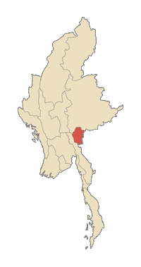
Kayah State (also called Karenni State) is a state of Myanmar. Situated in eastern Myanmar, it is bounded on the north by Shan State, on the east by Thailand's Mae Hong Son Province, and on the south and west by Kayin State. It lies approximately between 18° 30' and 19° 55' north latitude and between 94°40' and 97° 93' east longitude. The area is 11,670 km² (4,530 sq miles). Its capital is Loikaw (also spelt Loi-kaw). The estimated population in 1998 was approximately 207,357, according to UNICEF. It is inhabited primarily by the Karenni ethnic group, also known as Red Karen or Kayah, a Sino-Tibetan people.
Demographics
The state capital is Loikaw. The state is divided into 4 districts (Bawlake, Kantarawaddy, Kyebogyi and Mong Pai) which are divided into seven townships with 106 wards and villages.
 History
Mong Pai was a former British Shan State of Burma. It had an approximate area of 1000 sq. miles, and a population of 19,351 in 1901. The general character of the country was hilly, rising westwards from the chief stream of the Nam Hnilu or Balu.
In 1952, the former Shan state of Mong Pai was added to the Karenni States and renamed the Kayah State.
 Lefthit
No comments:
Post a Comment